


Descrição de FishTrack - Fishing Charts
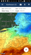
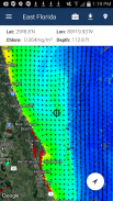
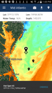
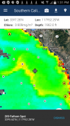
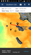
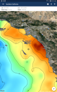
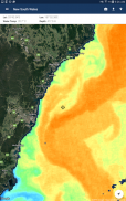
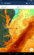
FishTrack provides saltwater anglers with everything they need to find fish. The FishTrack app offers free cloudfree sea surface temperature (SST) charts, global satellite imagery and marine weather forecasts – all in one layered tool.
With FishTrack you can:
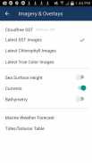
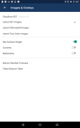
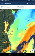
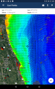
- View the latest SST, chlorophyll and true color satellite imagery
- Overlay bathymetry, ocean currents and sea surface height
- Save waypoints to mark fishing spots and catches
- Create routes to plan a trip and view distances and headings
- View marine weather forecasts and tides/solunar tables
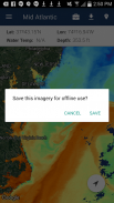
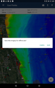
- Save fishing chart imagery for offline use
- View your current location both online and offline
Don't fish blind! FishTrack helps you plan a productive trip offshore. Burn less fuel and find fish faster.
We want to hear from you! Submit your questions or comments through our app to let us know what you think. If you'd like to speak directly with our customer service team, please e-mail us at: support@fishtrack.com.
FishTrack fornece os pescadores de água salgada com tudo o que precisam para encontrar peixes. O aplicativo FishTrack oferece gráficos gratuitos cloudfree a temperatura da superfície do mar (TSM), imagens de satélite global e previsões meteorológicas marinhas - todos em uma ferramenta em camadas.
Com FishTrack você pode:
- Ver a última SST, clorofila e verdadeiro imagens por satélite
- Batimetria Overlay, correntes oceânicas e da superfície do mar altura
- Salvar waypoints para marcar pontos de pesca e as capturas
- Criar rotas para planejar uma viagem e visualizar distâncias e posições
- Ver as previsões meteorológicas marinhas e marés / tabelas solunares
- Salvar pesca gráfico de imagens para uso off-line
- Ver sua localização atual tanto online como offline
Não peixe cego! FishTrack ajuda a planejar uma viagem produtiva offshore. Queimam menos combustível e encontrar peixes mais rápido.
Nós queremos ouvir de você! Envie suas perguntas ou comentários através de nosso aplicativo para que possamos saber o que você pensa. Se você gostaria de falar diretamente com nossa equipe de atendimento ao cliente, envie um e-mail para: support@fishtrack.com.
FishTrack provides saltwater anglers with everything they need to find fish. The FishTrack app offers free cloudfree sea surface temperature (SST) charts, global satellite imagery and marine weather forecasts – all in one layered tool.
With FishTrack you can:
- View the latest SST, chlorophyll and true color satellite imagery
- Overlay bathymetry, ocean currents and sea surface height
- Save waypoints to mark fishing spots and catches
- Create routes to plan a trip and view distances and headings
- View marine weather forecasts and tides/solunar tables
- Save fishing chart imagery for offline use
- View your current location both online and offline
Don't fish blind! FishTrack helps you plan a productive trip offshore. Burn less fuel and find fish faster.
We want to hear from you! Submit your questions or comments through our app to let us know what you think. If you'd like to speak directly with our customer service team, please e-mail us at: support@fishtrack.com.
FishTrack - Fishing Charts - Versão 1.3.1
(19-01-2024)
FishTrack - Fishing Charts - Informação APK
Versão APK: 1.3.1Pacote: com.fishtrack.androidApps na mesma categoria
Também podes gostar...


